Elementra Ltd — Capability Catalogue ↓ Download PDF
Capability Catalogue
Geoscience Consultancy
London, United Kingdom

Independent Subsurface Advisory

Geoscience insight for confident upstream decisions.

Elementra Ltd provides specialist geoscience consultancy across seismic interpretation, quantitative interpretation, exploration advisory, reserves and resources evaluation, depth conversion, acquisition and processing QC, and data science for geoscience.

20+years of global E&P experience
60+projects delivered worldwide
7core technical service lines
SPE-PRMScompliant reserves evaluation

Company Profile

Operator-grade subsurface work, delivered independently.

Elementra combines deep technical skill with commercial awareness. Interpretation is always framed around the decision it supports — whether that is a drilling location, farm-in assessment, field-development choice, reserves statement, licence application or investor-facing technical review.

What makes the work different

We work across the full subsurface chain: seismic data quality, structural and stratigraphic interpretation, rock physics, depth uncertainty, volumetrics, chance-of-success risking, and independent documentation.

Outputs are designed to be practical, auditable and decision-ready. The emphasis is not simply producing maps or slides, but reducing uncertainty in the questions that matter commercially.

Every assignment is scoped against a clear client decision. Assumptions are documented, ranges are quantified, and deliverables are structured for re-use, peer review and regulatory scrutiny.

Seismic interpretation

Approach

Four principles that guide every assignment.

From rapid screening to full-field integrated evaluations, the work is structured so clients can follow the reasoning, understand the uncertainties, and act on the conclusions with confidence.

01

Decision-led scope

Every workflow is built around the client decision: drill or defer, farm in, divest, sanction, audit, or reprocess.

02

Integrated evidence

Seismic, wells, petrophysics, pressure, production, analogues and regional context are brought together in one coherent model.

03

Transparent uncertainty

Assumptions, sensitivities and confidence ranges are clearly documented, not hidden behind single-number answers.

04

Audit-ready delivery

Reports, maps, tables and project archives are structured for re-use, peer review and independent scrutiny.

Services

Technical capability across the subsurface lifecycle.

Elementra supports operators, investors, independents and government bodies from regional exploration screening through appraisal, development, reserves evaluation and portfolio review.

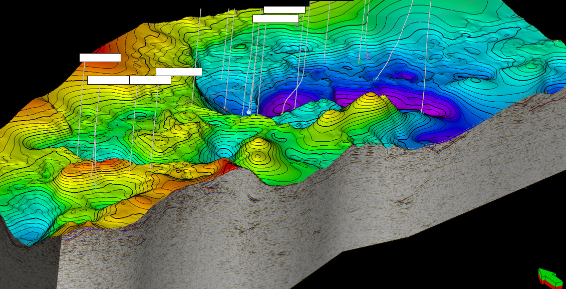
Seismic Interpretation

2D, 3D and 4D interpretation converting seismic volumes into defensible structural and stratigraphic frameworks.

  • Fault, horizon, salt and overburden mapping
  • Seismic attributes and spectral decomposition
  • Well-to-seismic calibration and geobody extraction

Quantitative Interpretation

Rock physics, AVO and inversion workflows that link seismic amplitudes to measurable rock and fluid properties.

  • Petroelastic modelling and AVO diagnostics
  • Acoustic and elastic simultaneous inversion
  • Facies, lithology and fluid prediction

Exploration & Prospect Generation

Play-fairway analysis, lead capture, prospect maturation and drill-ready technical evaluations.

  • Trap, reservoir, seal, source and timing assessment
  • Volumetrics and chance-of-success risking
  • Licence-round, farm-in and portfolio screening support

Reserves & Resources Evaluation

Independent, auditable evaluation aligned with SPE-PRMS, suitable for technical, investor or lender review.

  • 1P / 2P / 3P reserves and 1C / 2C / 3C resources
  • Monte-Carlo volumetrics and uncertainty ranges
  • CPR and reserves-audit support

Depth Conversion & Velocity Modelling

Velocity models and quantified depth uncertainty supporting prospect depthing, field studies and well prognosis.

  • Layered velocity modelling and horizon depthing
  • Geostatistical and probabilistic depth conversion
  • PSDM QC and post-drill recalibration

Acquisition & Processing QC

Independent oversight from survey design through acquisition campaigns, processing milestones and final delivery.

  • Survey-design review and vendor selection
  • Client representation and daily QC reporting
  • Pre-STM, Pre-SDM, broadband, OBN and 4D QC

Data Science for Geoscience

Machine learning and automation applied carefully to geophysical, petrophysical and production datasets.

  • Facies prediction and unsupervised clustering
  • Subsurface property prediction with uncertainty ranges
  • Reproducible Python and notebook workflows

Deliverables

Outputs that can be reviewed, defended and reused.

The final package is tailored to the audience — internal technical teams, boards, investors, lenders, licence authorities or external auditors.

Interpretation packages Mapped horizons and faults, seismic facies, attributes, geobodies, well ties and technical notes.
Prospect inventories Lead and prospect registers with risk, volume ranges, ranking and drill-readiness indicators.
Depth uncertainty ranges Depth-converted surfaces, velocity-model assumptions and volumetric uncertainty impact.
QI feasibility summaries Rock-physics diagnostics, AVO response expectations and inversion-readiness recommendations.
SPE-PRMS resource tables Reserves and resources summaries, deterministic and probabilistic, with full uncertainty ranges.
Executive briefings Board-level messages with key risks, ranked recommendations and clear next technical steps.
Step 01

Scope

Clarify the business decision, available data, constraints, schedule and required deliverables.

Step 02

Review

Assess seismic, well, petrophysical, production and regional information for quality and gaps.

Step 03

Evaluate

Run the technical workflow, integrate evidence, test alternatives and quantify uncertainty.

Step 04

Deliver

Provide decision-ready maps, reports, tables and recommendations with a clear audit trail.

Global Reach

Experience across mature, emerging and frontier basins.

Over 60 projects spanning exploration, appraisal, development, processing QC, licence rounds, reserves and independent technical review.

World map showing Elementra project locations
UK Continental Shelf — Outer Moray Firth, Central and Northern North Sea
Norwegian Sea — Vøring margin, Gjallar Ridge basin studies
Middle East — clastic and carbonate plays, exploration to development
North and West Africa — frontier basins, licence-round evaluation
South and Southeast Asia — reserves evaluation and prospect maturation
Americas and Oceania — independent reviews, audits and CPR support

Elementra Ltd

Independent geoscience advice for complex subsurface decisions.

For a focused independent review, prospect evaluation, integrated field study or audit-ready reporting, Elementra provides practical technical support tailored to the decision in front of you.

Get in Touch

info@elementra.co.uk www.elementra.co.uk London, United Kingdom